
By Dr Tristan Jenkinson
Introduction
This week was the start of what promises to be a month of challenges from Bellingcat. Based on their posts across social media (e.g. https://bsky.app/profile/bellingcat.com/post/3lccsanaews2l), for five days a week each week in December, they are setting a new open source problem to be solved.
You can solve them to gain access to the next, or wait until they unlock day by day.
On Monday (2 December), the first set went live, and I have written my notes up here.
This week, all of the challenges were geolocation based (i.e. where you are given an image and you identify where it was taken). It is not clear if this will be the case for all of the month’s challenges – I suspect that there will be some variations thrown in as there are plenty of different types of open source problems that they could be throwing out.
I wanted to share the approaches that I took, and would love to see alternative approaches (there will be far better ways to complete these I am sure!).
Let’s start with the first Challenge.
A Sticky Situation

So, we have a mountain scene with a large cable line present. As we are in the mountains this could well be a line for a cable car or ski lift. We will return to the scene shortly.
We also have a number of stickers to consider. The majority of these appear to be in Germanic language. We have a few points to note, for example, a QR code for an Austrian website, an “I Love Hiking – Group Macedonia” sticker, with an Austrian flag, a sticker with a ram logo and text “@dersteinbocklinz”, and a sticker for “Bergbuddies Zillertal”.
Looking up “@dersteinbocklinz” we can match the logo to an Instagram account with the same name – https://www.instagram.com/dersteinbocklinz. This appears to relate to a rock climbing location in Linz, Austria.
Bergbuddies Zillertal appears to be a hotel in Zillertal, which is a location in Austria often used for skiing. This would tie in with the potential cable car cable in the image. Doing some quick digging, we can see that there are a number of cable car systems around the Zillertal area – e.g. the below from https://www.zillertal.at/en/summer/holiday/zillertal-summer-cable-cars.html:
Opening hours of the summer cable cars
| Cable cars | Summer season schedule |
| Spieljochbahn, Fügen** | 24.05. – 26.10.2025 |
| Rosenalmbahn, Zell am Ziller** | 07.06. – 31.08.2025 |
| Gerlossteinbahn, Hainzenberg | 29.05.-19.10.2025 |
| Isskogelbahn, Gerlos* | 06.06. – 09.06.2025 bzw. täglich 14.06. – 12.10.2025 |
| Königsleiten Dorfbahn | 14.06. – 05.10.2025 |
| Ahornbahn Mayrhofen, Mountopolis | 14.06. – 31.10.2025 |
| Penkenbahn Mountopolis* | 29.05. – 12.10.2025 |
| Finkenberger Almbahnen* | 07.06. – 26.10.2025 |
| Eggalm Bahnen, Lanersbach* | 19.06. – 12.10.2025 |
| Hintertuxer Gletscher* | Open all year round |
Going back to the mountain view, there are a few details that are worthy of note.
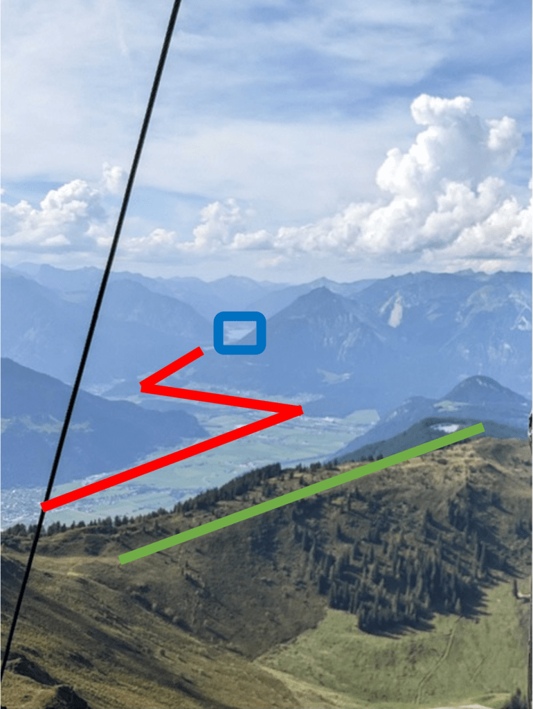
In blue we see what appears to be some water in the background, we also have an ‘S’ shaped valley highlighted in red in the image, and a tree lined ridge in green.
I started by looking up Zillertal in Google Earth, and looking to see if I could match up any features.

We can see that there is a lake to the north west, and we have two valleys which would form an ‘S’ depending on the angle it was viewed from. There is also plenty of green which could represent the tree lined ridge.
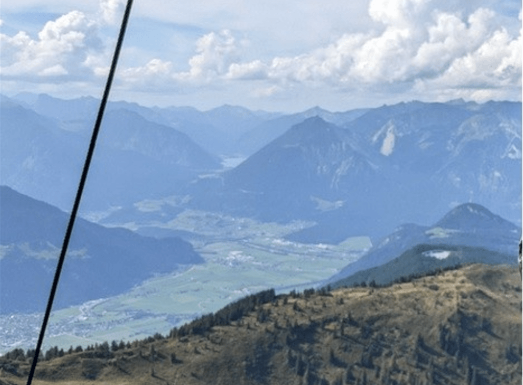
Putting the terrain option on in Google Earth, and coming down to see if we can line up an image, I was able to find the below view:


Here we can see the lake in the distance, with the valleys forming the ‘S’ seen in the example, as well as a potential ridge for the treeline.
This does tie up with some of the main features, and many of the peaks appear to be in the right place, but it can be difficult to tell within Google Earth.
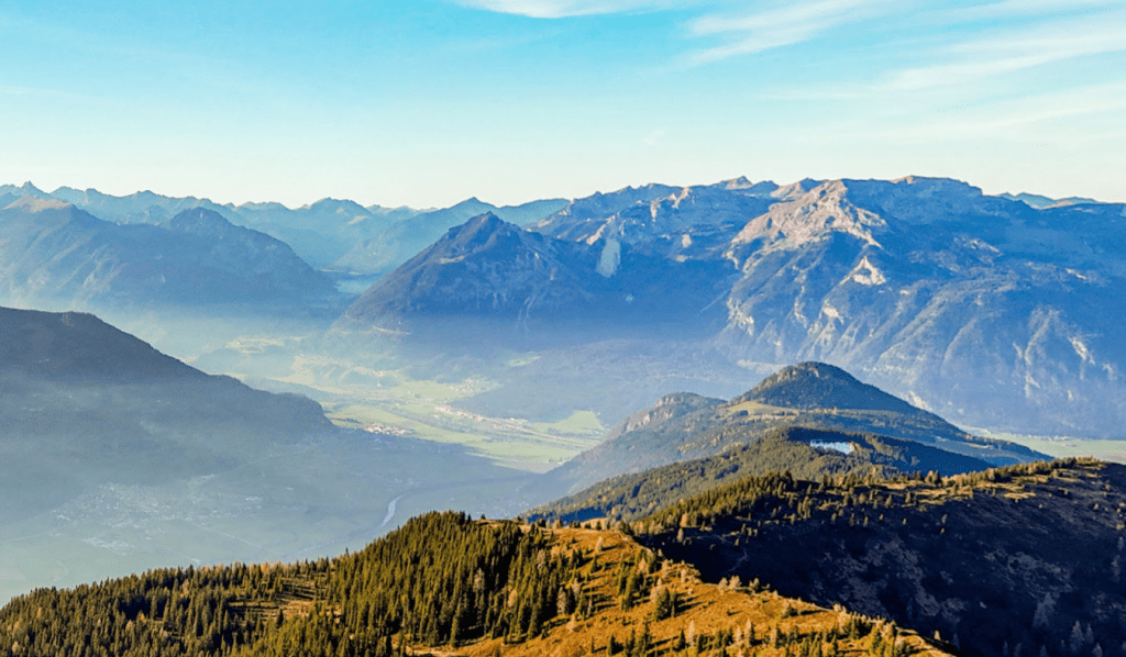
Using Google maps, I was able to find a number of photographs in the right area, and the first of these seems to match the area we are looking at.

Compares to the image we are looking for (below):
This is very close. Near to this location on Google maps is a location labelled as “Top of Alpbachtal” which is the Top of the Alpbachtal Viewing Tower. Finding photographs near there on Google maps, we can find the below from Michael Holley:
Looking up information on the Alpbachtal Viewing Tower, you can find that it is situated on Wiedersberger Horn (see for example https://www.skijuwel.com/en/winter/more-outdoor-activities/top-of-alpbachtal).
This is indeed the answer we are seeking.
Solution: Wiedersberger Horn
Flamin-Go Find It!

One of the first things to note here is that there are several different types of flamingo. The flamingos in the photograph here appear to be Chilean flamingos, which can be really helpful in narrowing down.
Running searches for Chilean flamingos and using Google images, I was able to find the below image

This looks very similar, with the same style of flooring, fencing and a green background behind the fencing. We also have the same edging around the water, and bubbles in the water in the same area as seen in the image we are seeking to locate.
The site where this photograph came from is https://seattlerefined.com/lifestyle/gallery/photos-carson-the-red-panda-pumpkin-bash-at-woodland-park-zoo-seattle-halloween-animals-spooky-season?photo=14.
Another photo from the same site includes a building in the flamingo enclosure:

This appears to match the tiling seen in the image we are looking to match (shown below):
This does then seem to be likely the correct location. This is the Woodland Park Zoo in Seattle.
The question asked for the name of the area in which the flamingos were found, so my initial reaction was to find the area of the zoo where the flamingos are located.
To do this, I found the zoo’s main page to find their map – https://www.zoo.org/maps.
If you then locate the flamingos, they are in an area called Temperate Forest:

However, this is not the answer that we are looking for.
The answer is simply the name of the zoo.
Solution: Woodland Park Zoo
Note – Given the text here specifically mentions that there were (apparently) thirty one flamingos, I did think that this might be a clue. Running a search for “31 Chilean flamingos” identifies an academic paper (https://www.google.com/url?sa=t&source=web&rct=j&opi=89978449&url=https://www.rhodes.edu/sites/default/files/RJBS%25202017%2520edition%2520final.pdf&ved=2ahUKEwjBjr_pwZiKAxVvVkEAHY6TN_wQFnoECBoQAQ&usg=AOvVaw1pbFUW63eDnCIAXsuBoi_y) which identifies that Memphis Zoo has thirty one flamingos, but this is not the right location.
The search for thirty one flamingos also identifies a Blogspot article talking about the Franklin Zoo, stating “With the new additions, the zoo now has 31 Chilean flamingos in its collection” (https://amandabout-town.blogspot.com/2008/08/meh.html?m=0). Sadly, again, this was not the right location.
Pulling Focus

Zooming in on the sign on the building and using a deblurring tool (Topaz AI), I was able to get the below image of the sign:
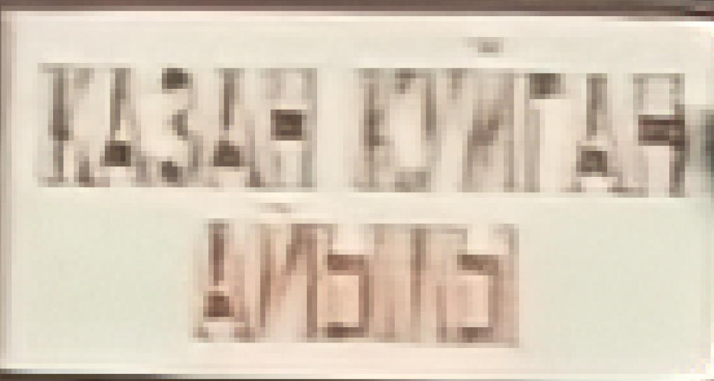
Then using a list of Russian characters (https://www.linguanaut.com/learn-russian/alphabet.php), I looked to match these up. This was relatively straightforward for the first two words:
КАЗАН КУЙГАН
I was not sure about the last word. However, putting these two words into a Russian English translation (Google Translate), it was possible to identify that they represent a location – Kazan Kuygan, in Kyrgyzstan.
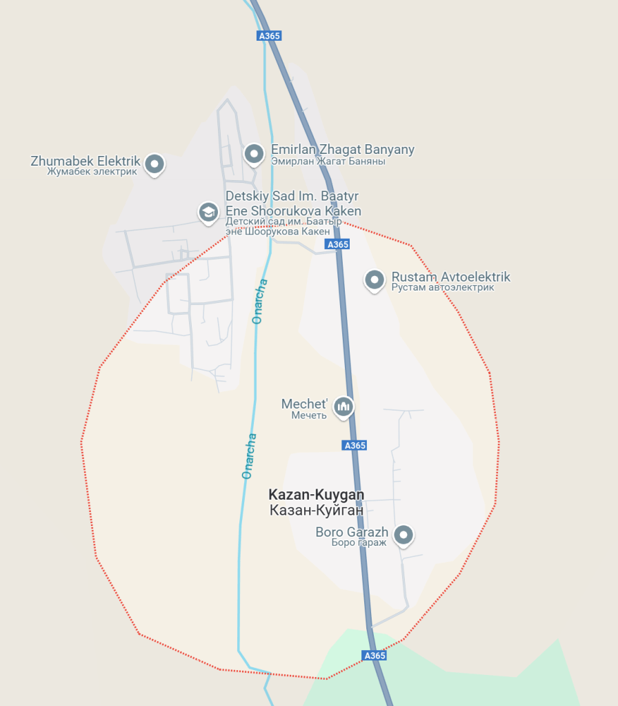
This is quite a small location, as shown below on Google Maps:
Using Google Earth, I was able to look for the same location, and found the below:

Compare to our image that we are looking to locate (below):

We can see that the sign and the flag on top is present in both, we can also match the telegraph pole, the low white building on the right, and what looks like the start of the roof of the larger white building behind this. The mountain position also matches in the background.
The birds-eye view in Google Earth shows that this building is labelled as “Biblioteka”, as below:

The building is therefore a library, and this is the solution that we are looking for.
Solution: Library
The Rider’s View

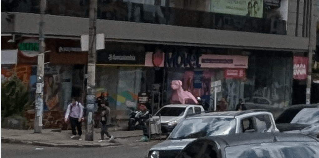
Zooming in on the car to the left hand side, we can see the license plate:

We can also see a license plate on the car behind, though we cannot make out the text, we can see that it is also yellow:
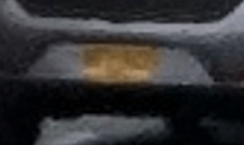
Looking up licence plate information from Geohints (https://geohints.com/LicensePlates), the plates that we can see are consistent with Colombia:

It appears that we are in a city. By far the largest city in Colombia is Bogota (https://en.wikipedia.org/wiki/List_of_cities_in_Colombia_by_population), so this is a good place to start.
Zooming in on the shops on the left hand side of the photo, this appears to be called “movet”.
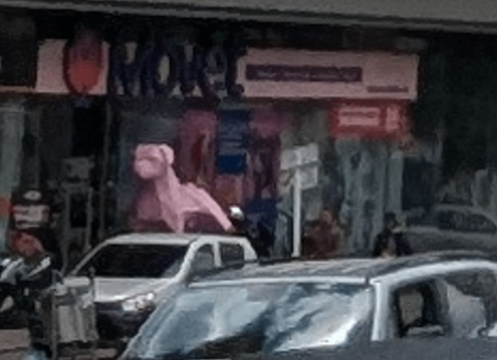
Running a search for movet, we can find this is a vet in Colombia:

The logo also matches the logo on the sign of the shop. So this appears to match.
We can therefore look to see if we can identify the location of different branches. Running searches, I found the below image on a website (https://ioverlander.com/places/249699-movet-chapinero), which mentions “Very nice vet office in Chapinero”.

Searching for Movet’s Chapinero office, it can be found in Google Maps, which has the corresponding street view:
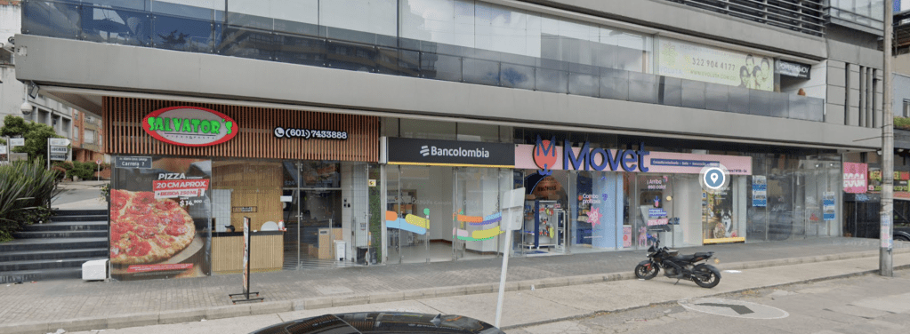
Compare this to the shops from the original image:
These shops match, so it appears that we are in the right place.
This is the location in Google Maps:
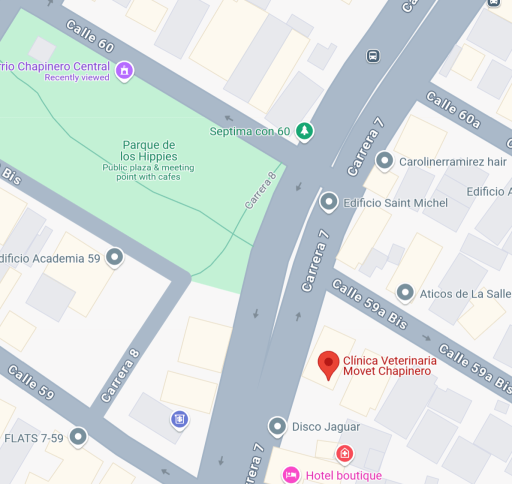
So the motorcycle would just be turning up Calle 60.
If we use street view, we can see a monument:

We do not have the detail to see who this is a monument to, but we can see on the main map:

Remember, the aim was to identify the name of the person who this was a monument to.
Solution: Julio Florez.
Lost in the Fog
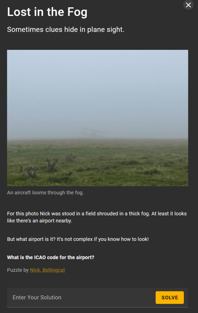
There is very little information in the image itself, so there must be more to this. Utilising my digital forensic background, I immediately opened up the properties, and we have GPS information:

This is not in the more typical decimal format that we often see for latitude and longitude, this sets up the degrees, minutes and seconds.
This format can still be used directly in the Google Maps search functionality, as below:

Putting the values into Google Maps:
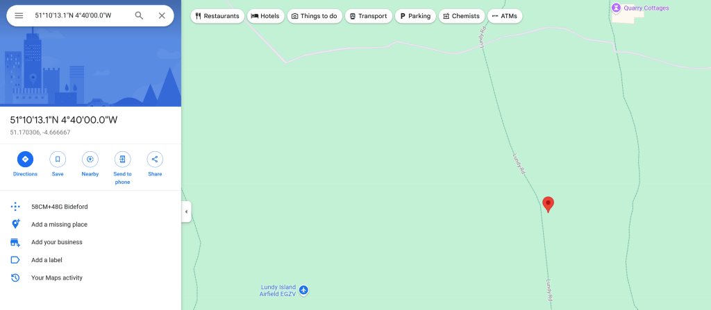
We are near to Lundy Island.
Checking the information on Luncdy Island to confirm the ICAO code, we can use https://metar-taf.com/airport/EGZV-lundy-island-airfield:
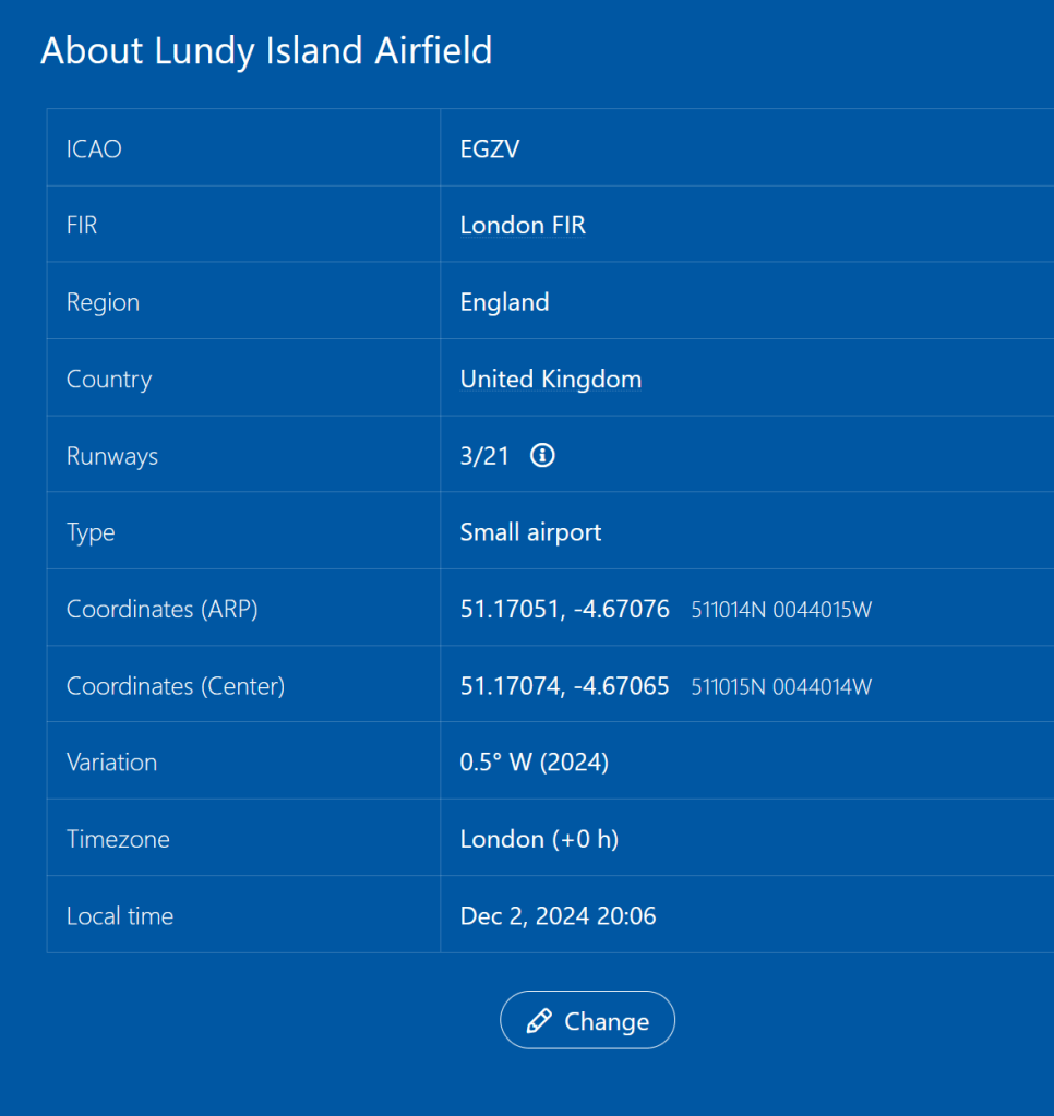
So the code we need is EGZV.
Solution: EGZV.

For the first one I looked at Foeke’s social media posts to see if I could work out where he was in August 2022. Nothing on Twitter and his IG was locked down, but his LinkedIn profile showed he was at a conference in Alpbach, and when I put that town into Google, the same post and metal box came up.
LikeLike
Cunning.
I’ve seen something similar on digital forensic CTFs, where you can research posts/articles that the CTF authors have made, liked or referenced. Often you can find write ups on artifacts that relate to exactly what you are looking for.
Thanks Alex!
LikeLike
Thanks for helping me out with those flaming flamingos!
I don’t normally ‘cheat’ with these sorts of challenge and when searching I would generally bypass a site whose summary suggested it contained a ‘walkthrough’, but in this case I was stumped so I clicked. It turned out I had the right location but had only tried ‘Seattle Woodland Park Zoo’ and ‘Woodland Park’ as options. I hadn’t tried just ‘Woodland Park Zoo’. If I hadn’t found this page, I might have moved on from Seattle altogether and wasted days looking elsewhere, even though I was utterly convinced I’d found the right place.
I’d already solved all of the other puzzles (nine out of ten at time of posting) so at least I didn’t have to worry about spoilers for anything else.
BTW I also thought the 31 might be a clue and wasted a good hour looking at zoos in California, with it being the 31st US state. Sigh. Sometimes a number is just a number. 😉
LikeLike