
By Dr Tristan Jenkinson
Introduction
This month Bellingcat are running a series of OSINT challenges, each week a new set of five challenges is posted for that week. The “Natural Wonders” series finished on Friday. If you haven’t already been playing along (and why not?!) you can join in at challenge.bellingcat.com (Spoiler warning- the rest of the article contains solutions for week 4).
Let’s jump into the week 4 challenges.
Up the Creek

I started off putting the image into geospy.ai, and got the below result:

With an estimated location as below:

This area seems like a good place to start. I fired up Google Earth, but needed something specific to look for. Looking at the photo we are looking to locate, there are a few points of note. We are looking for an area between two heavily wooded areas. We also have a small bridge, but there are also what look like two squares of trees which are quite well defined.
This is the bridge:
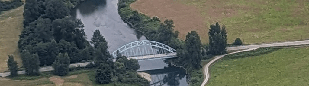
Below are the two squares of trees, one very well defined and the other less so:

We also have a main road on the left hand side of the image.
Starting in the area suggested by Geospy.ai, I looked for squares of trees similar to this, and they were quite straightforward to find. As seen below, the well defined square in blue, and the less defined in green:

Obviously this is oriented differently to the original image. We can see that there is “Novelty Bridge” on the right hand side. This is indeed the bridge in the image.
If we reorient this in Google Earth to match the photo, we can swiftly find this match:
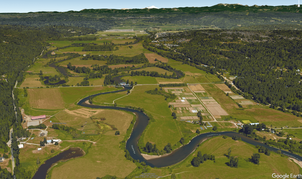
Compared to the image we are looking to locate:

A clear match.
Google Earth identifies that the river is the Snoqualmie River.
Solution: Snoqualmie
Hot Stuff

The first thing that I did was to zoom in. We can see from the below that we have the number 21, and possibly 117 or 112 written on the tail. It is not possible to make out the registration code on the tail:

I then ran a Google image search focussed on the helicopter, as below:

This returned a number of results. As I was hoping for, some are from spotting sites including planespotters.net. Following one of those links (https://www.planespotters.net/photos/aircraft/eurocopter-as-350?sort=date) we can find the image below at https://www.planespotters.net/photo/1628788/ec-kzl-bombers-generalitat-de-catalunya-eurocopter-as-350b-3-ecureuil.

This looks very similar, with the same layout, colourings and text. We can see from the details posted that this is run by Bombers – Generalitat de Catalunya (i.e. the Fire Brigade of the Government of Catalonia).

As the helicopter we are looking for is similar, we can use the cross check to look for all the viewings for helicopters from “Bombers – Generalitat de Catalunya”.
This search (https://www.planespotters.net/photo/search?airline_text=Bombers+-+Generalitat+de+Catalunya) finds 6 photos.

One of these looks like our number 21 helicopter in the image that we are looking to identify.

If we open up that image, we can see the details for that helicopter at https://www.planespotters.net/photo/1611269/ec-mqr-bombers-generalitat-de-catalunya-eurocopter-as-350b-3-ecureuil

We can also see from the photo, that the number on the tail is 112, so this appears to be a potential match to the image that we are looking to identify.
Based on the above search, we can see the serial for the helicopter is 4914, and we can see the tail reference is EC-MQR.
Running another search on the planespotters site for serial 4914, we get 5 results. The most recent of which is 11 July 2024 – https://www.planespotters.net/photo/1628786/ec-mqr-bombers-generalitat-de-catalunya-eurocopter-as-350b-3-ecureuil
This image shows the helicopter with number 11.

There is also a note on the sighting, stating that this is an update of the fleet number – as seen below:
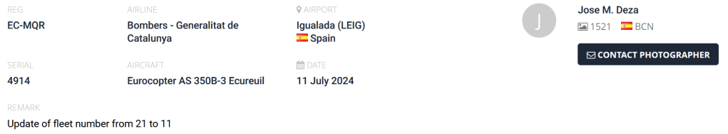
This does indeed appear to be our helicopter.
We can also see the tail reference that we want is EC-MQR, unchanged from when it was number 21.
For the solution we need the tail reference and the large number, so we have:
Solution: EC-MQR-11
Alpine Adventure

The mountain in the background looks like it would be fairly unique, so I wanted to start there.
Putting this into Google Images, and focusing just on that mountain, I got the responses below:

From the responses, it does look like we have some good matches, and they are in the Rocky Mountain National Park.
Selecting one of the matching images, I got to https://www.usgs.gov/media/images/rocky-mountain-national-park.
This site contains the below image with the text “Scenic shots of Rocky Mountain National Park, near Bear Lake”.

We may therefore be looking at Bear Lake.
Running a quick Google for Bear Lake Rocky Mountain, I looked at the images and was able to find this picture from https://www.uncovercolorado.com/activities/bear-lake/:
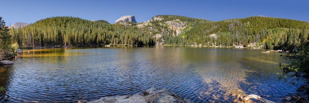
We can compare the relevant area of this to the image that we are looking to locate:

This is a good match.
Solution:Bear Lake
Pet the cat

We are looking for a location, which is really nothing to do with the cat… so as difficult as it is for me to say it, we just need to ignore the cat (if you want pictures of cats, I can recommend BlueSky!).
The building in the background is interesting with wooden shutters (if you zoom in you can see that these have horizontal slats). We can also see an interesting light on the side, which may help us to locate this building. The red sign is also interesting, especially as it is not square. Zooming in we can see that it is more scroll shaped, which is quite unusual:

We can also see an intricate structure/sculpture to the right of this:

This intricate stonework could potentially indicate a chapel or religious location.
Note that Geospy.ai gives us the below:

This is not a lead that I followed, as I was focused on the light, the sign and the building in the background.
Using Google Images, I used the below focus:

This led me to the following image:

In particular note the stone buildings, and the red sign, in the shape of a scroll, as we saw in the image that we are looking to locate.
If we follow that link, we get to https://www.booking.com/hotel/me/lana-amp-ena-apartments.en-gb.html?activeTab=photosGallery, where we can ask to show the location on a map:

From the map, we can see that we are in Kotor, Montenegro.
I then moved to street view to see if I could match up any details. I went south a couple of blocks and was able to find this location, facing the Cathedral of Saint Tryphon:
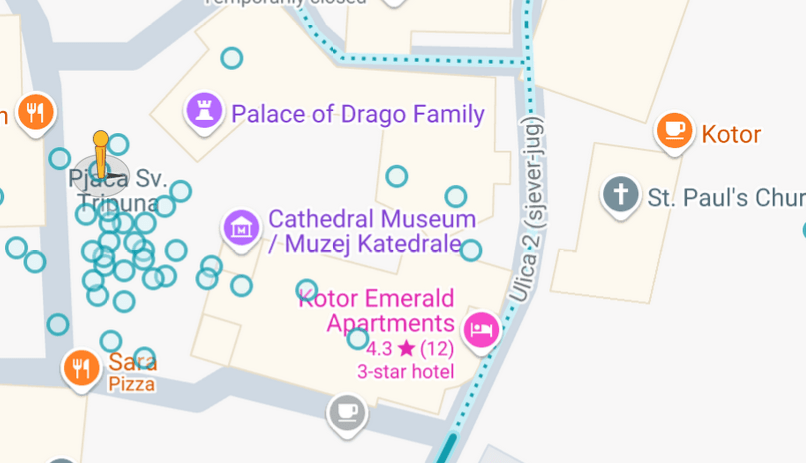
The view looks like this:

Details here significantly match with those in the image to be located, though from a different orientation. Points that match include the light, the red sign, the large corner brickwork, the table/sculpture object, and a ramp:
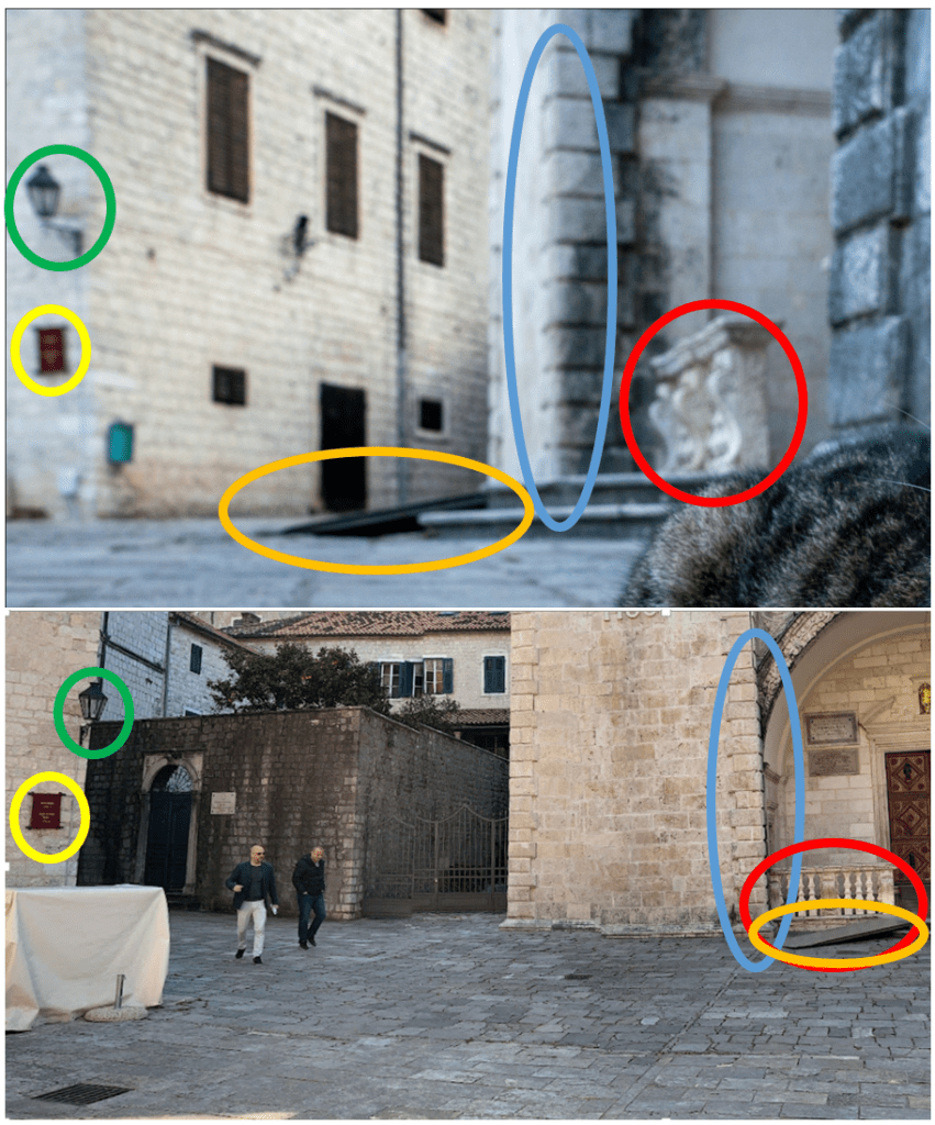
The building on the left also has the correct windows and shutters, with horizontal slats
This very much matches the location where the photograph of the cat was taken. The old town of Kotor is also well known for its street cats!
Solution: Kotor
Two Tired
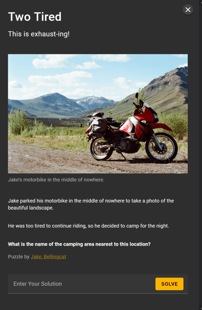
Running the image through geospy.ai, we get the below response, together with a suggested location in Yukon.

Based on this location, and the fact that we are looking for a camping area, I ran a search:

I did then do some digging which didn’t take me much further, looking into the creator of this challenge (Jake Godin), finding an article on his about long distance motorbike trips (https://districtfray.com/articles/jake-godin-motorcycle) which mentions a few specific locations that he has travelled to. I also found a GitHub page with a photo of Jake with some mountains in the background. I thought that this may be from a similar location, but (using Geospy.ai) they appear to be in California, so likely a separate trip. I also used an online tool to remove the motorbike from the image to be located, to try and minimise the focus of analysis tools on the motorbike to see if this gave better results, but I didn’t get much more from Google Images or Geospy.ai.
I therefore decided to take an indirect approach, and look at the camping grounds in Yukon to see if there was a likely match. I had the list of four main locations from the Google Search above, but wanted to see which was the most popular.
I Googled most populate camping in Yukon near mountains.

The AI response was supported by a further search result:

So it looks like Tombstone is the most popular, I decided to start there.
I found the campground, and went to street view on the road that leads to the camp. I was planning on looking around to see if there was anything that might be a possible match, however, upon opening streetview, I saw the below:

This was just outside the campground on the Dempster Highway.
Compare the mountains in the background to those in the image we are looking to locate:

This is a very good match.
I followed the road a little way, looking to find a more direct match, but in many of the images the mountains are obscured by cloud.
Regardless, it is clear that this is the location that we are looking for, and since we are on the road just outside the Tombstone Campground, this must be the camping location that we are looking for.
Solution: Tombstone Campground
